Location:
Being a part of the Konkan region, Alibag is bound on the north and west by the sea, while on the south by the Kundalika River and Roha, and on the east by the Amba River and the village of Nagothna. Alibaug and its entire vicinity is well connected by roads and waterways. The nearest airport is Mumbai or Pune and the nearest railway station is Pen.
History:
The entire area in the vicinity of Alibaug which includes the villages of Revdanda, Chaul, Nagaon, Akshi, Varsoli, Thal, Navgaon, Kihim, and Aawas were together known as “Ashtagare” (Eight Villages). It has been a home to several communities like Hindus, Muslims, Portuguese Christians, Bene Israel Jews and Parsis. Apart from being famous for its picturesque beauty, this region also holds a great historical significance. Alibag, is a combination of two words: ‘Ali’ that is a name of a person and ‘Bag/Baag/Baug’ that is garden. Thus, Alibag/ Alibaug can be translated as ‘Ali’s Garden’. It is said that the name comes from a rich Bene Israeli person named Ali/Eli, who dug many wells and gardens in the area. He had several mango and coconut plantations in his gardens. Hence the locals called it “Alichi Bagh” which with time became Alibaug.
Ten or eleven of Ali’s wells remain. The two best known are the Pimpal well near the large banyan tree close to the Mamlatdar’s office (local administrator) which also is said to house Ali’s tomb, though this claim is sometimes contested; and the Ganpati well in front of Ganpati Temple. The site of the present town is said to have formerly been covered by the sea. According to local tradition the old settlement was at Ramnath, three quarters of a mile to the north of Hirakot, and Ali’s garden was converted into the present town towards the close of the seventeenth century, when Kanhoji Angre made it his head-quarters.
Chaul, which is a small village located in Alibag Taluka has been one of the most important and active ports for trade. It remained a centre for flourishing trade and cultural interactions with foreign countries since the 1st century CE till the colonial period. It has also been one of the most described places by the foreign travellers and writers. Inscriptions dating between the 1st to 5th centuries which have been found in the Kanheri caves in Borivali (Mumbai) mention this port as ‘Chemula’. The economy of Konkan was sound and stable in the historical period because of the overseas trade from Chaul. The political struggle between the Marathas, Mughals, Siddis, Portuguese, etc. for obtaining the control of Chaul explains the importance of this port for commerce.
Socio-Cultural Dynamics:
This entire extent not only has a rich economic and political history but also a flourishing socio-cultural history. From ancient days, it has been a settlement with variety of religious and cultural population. Hindus contribute to the highest percentage of population which are further split in castes and communities like Paanchkalashi, Bhandari, Sonar, Kunbi and Koli (fishermen) etc. Several Muslims who came here from Arabia for trade settled here permanently. They form a community known as ‘Kokni Muslims’ and reside in Revadanda, where they have dedicated pockets called as ‘Mohallas’. They are involved in bakery, trade and also fishing. Then came the Parsis and Jains, who today are spread in different areas in Chaul and Revadanda and are mostly involved in trade.
One interesting community which is based here is that of Bene-Israeli (Sons of Israel). These are a community of Jews who survived the shipwreck of refugees from persecution or political turmoil, and landed at Navagaon near Alibag. As the legend goes 14 Jewish men (7) and women(7), arrived in India sometime in the first or second century C.E. when they were shipwrecked here while on a trading voyage to the far east. They were oil-pressers and were locally known as the ‘Shanivaar Telis’ (Saturday oil-pressers) as they did not work on Saturdays. Apart from running the coconut oil extraction business, they also carried out other trades like beetle nut, fruits, spices etc. This story is similar to one of the stories narrating the emergence of another Konkan based community, the Chitpavan Brahmins (also called Kokanastha Brahmins).
Christianity came into practice with the Portuguese and has stayed here with the Portuguese Christians and many native converts. A part of the population living in Korlai also has their special language ‘Christi’ which is a creole (a mixture of Konkani, Marathi and Portuguese languages).
Highlights of the Location:
This vast expanse also has several monuments and places of interest which stand testimony to its diverse history, culture and nature. The region is also a storehouse of forts and fortresses.
1. Janjira Fort:
The word ‘Janjira’ means a ‘sea fort’. Janjira is a fort situated on an island just off the coastal town of Murud. The fort was originally built in the 16th century by Raja Ram Rao Patil, the chief of Kolis for protection against the pirates. When he did not comply with the orders from the Sultan of Ahmadnagar, the Sultanate sent Piram Khan to attack this fort. The fort reached its zenith under the Siddis who originally came as African slaves but built their empire and took charge of a significant piece of the coastline of Maharashtra. Janjira became the centre of their empire. The most significant fact about this fort is that it remained unconquerable till it was passed down to the British in 1818. Several remnants seen on the fort today are a reminder of its hay days. They include two huge sweet water lakes, palace of the Siddi, thick walls, nineteen bastions, three huge cannons (Kalal Bangdi, Chiavari and Landa Kasam) , etc.
2. Revadanda Fort:
Revadanda Fort is located on the southern side near Kundalika River. This Fort was built by Portuguese in mid-1520s. There were several cannons in the Fort for defence of Chaul port. There are several churches inside the fort. A Portuguese inscription mentions this fort as ‘Fortaleza de Chaul’ (Fort of Chaul). At the time of Coronation of Shivaji Maharaj in 1654, the English lawyer Henry Oxenden had stayed at Revadanda Fort.
3. Korlai Fort:
Korlai fort is built on a rocky bar on the other side of the Kundalika River. This was built around 1520s and Burhan Nizam Shah made this fort stronger by having additional walls and fortification in 1680s. It was named as ‘Murud Chaul’ by the Portuguese. Sambhaji Maharaj attempted to win Korlai, but he did not succeed. Later in 1739 Chimaji Appa, brother of Peshwa Baji Rao I, won this fort, but had to return the fort to the Portuguese as per treaty terms. After a few years Peshwas won that fort and handed over it to Angrias who started a factory to cast cannons. In 1818, after the defeat of Peshwa in Third Anglo-Maratha War, this fort was handed over to British.
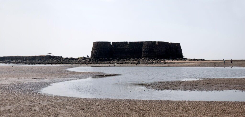
4. Kolaba Fort:
The Kolaba Fort also known as the Alibag Fort is located to the south-west of Alibag. This was chosen to be fortified by Chhatrapati Shivaji Maharaj. The construction was completed in 1681 and it became an important station for naval forces of Marathas which was controlled by Kanhoji Angre. Kanhoji Angre, the chief of Maratha Navy, passed away in this fort. One of the interesting features of this fort is that despite being surrounded by the sea on all sides, one can find freshwater wells inside the fort. One can also see several old temples and an old dargah in the fort.
5. Hirakot Fort:
Hirakot roughly translated as the Diamond Fort, is said to have been built by Kanhoji Angre in 1720s and was used by him as his administrative headquarters. This fort shined in sunlight as it was built up of big blocks of black basalt, hence the name ‘The Diamond Fort’. Hirakot remained in the Angre family’s control up-to 1840; thereafter it passed to the British. At present, parts of the Hirakot Fort are used as a District Jail.
6. Khanderi:
This island was occupied and a fort was built here in late 1670s during the reign of Chhatrapati Shivaji Maharaj to keep a check on the Siddis at Murud-Janjira fort. This fort saw a lot of battles between the Siddis and the Marathas. The fort was later handed to the English East India Company after the Maratha defeat in 1818. Khanderi island was renamed Kanhoji Angre Island in 1998, in honour of the Maratha Admiral Kanhoji Angre.
7. Underi:
The fort of Underi, also known as Jaidurg, is a sister fort to Khanderi. After seeing the increasing Maratha influence in this area the Siddis built a fort on this island in 1680. Underi is smaller than Khanderi. There were several unsuccessful attacks by the Marathas to conquer the Underi fort. Later the fort was taken over by the English after their victory over the Siddis.
8. Khubladha Fort:
The fort is to the east of Khanderi Island and was built to protect the Khanderi Fort. It was built on a natural elevation on the Thal coast. In 1659, when the Khanderi fort was being built, Khubladha served as an offshore base for men and material and also protected any invasion on the land from British or from the Siddis. In 1749, Siddi conquered the fort only for it to be taken back by Manaji Angre a year later. After a few years, the fort was abandoned and the base was moved to Kolaba fort.
Religious Monuments:
There are several temples in the entire region along with mosques, synagogues and churches due to a culturally diverse population. There is also the temple of Goddess Kalambika, the family goddess of the Angres.
1. Kankeshvar:
A famous Shiv temple located on a 5000 feet high hill and is located approximately 13 kilometres from Alibag. The temple has a Pushkarni (sweet water tank) enclosed in traditional structure of red stone.
2. Ass-Curse stones:
In Akshi there are two temples, Kalkaborva Devi and Someshvar Mahadev. Close to the Devi temple one can see an inscribed stone 4′ 3″ long by 1′ broad. Above are the sun and moon followed by the ass-curse and an inscription of nine lines in the Devanagari. Also close to the left of the Someshvar temple is an inscribed stone, 5′ 5″ long by 1′ 3″ broad. Above are the sun and moon followed by fifteen lines of writing in the Devanagari character and below the writing is the ass-curse. These ass curse stones are known as “gadhegals” in Maharashtra. They are stone engravings depicting donkeys in sexual union with women. It represents a curse stating that the violator will be cursed if the order mentioned in the edict is violated. A number of such inscribed “gadhegals” have been found from the Konkan Coast.
3. Alibag Magnetic Observatory:
One of the world’s longest running observatories was set up at Colaba (Bombay) in 1841, which was shifted to Alibag between 1904 and 1906 to avoid electric traction effects on magnetic recordings. There are huge and complex instruments in operation in the observatory which can be seen from the outside. It has two adjacent buildings: one to record changes occurring in the geomagnetic fields and the second building collects data about geomagnetic storms caused by solar storms.